Łomianki Dolne
Łomianki Dolne | |
|---|---|
Village | |
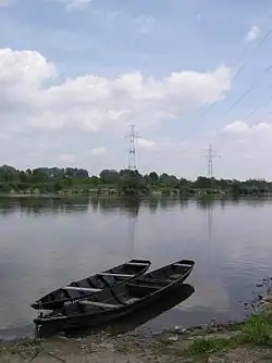 Vistula River at Łomianki Dolne with a powerline crossing in the background | |
 Łomianki Dolne | |
| Coordinates: 52°22′N 20°54′E / 52.367°N 20.900°E | |
| Country | |
| Voivodeship | Masovian |
| County | Warsaw West |
| Gmina | Łomianki |
| Population | 180 |
| Time zone | UTC+1 (CET) |
| • Summer (DST) | UTC+2 (CEST) |
| Vehicle registration | WZ |
Łomianki Dolne [wɔˈmjaŋki ˈdɔlnɛ] is a village in the administrative district of Gmina Łomianki, within Warsaw West County, Masovian Voivodeship, in east-central Poland.[1] It lies approximately 4 km (2 mi) north of Łomianki, 18 km (11 mi) north of Ożarów Mazowiecki, and 18 km (11 mi) north of Warsaw.
References
- ^ "Główny Urząd Statystyczny" [Central Statistical Office] (in Polish). To search: Select "Miejscowości (SIMC)" tab, select "fragment (min. 3 znaki)" (minimum 3 characters), enter town name in the field below, click "WYSZUKAJ" (Search).
| Town and seat |  | |
|---|---|---|
| Villages | ||